Water ice + drytooling / WI3 – WI5, M4 – M7 Base: Cogne village, 4–6 climbing days
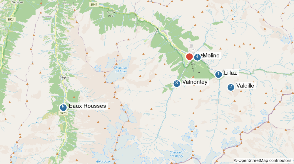
Base Cogne (red)1 Lillaz 8 min · 2 Valeille 8 min + 15-45 min walk · 3 Valnontey 6 min + 40-75 min walk · 4 Moline 3 min · 5 Eaux Rousses ~1 h 15 drive
When to go
Target the end of January. The season runs 1 December to 31 March and January–February is the core of it
Draft plan
Aspect
Behaviour
When to climb it
Valeille, west side
Shady
Reliable; E Tutto Relativo, Stella Artice, Cold Couloir
Any day
Valeille, east side
Sunny
Tuborg, Candelabro — softens through the afternoon, goes rotten late season
Early start, early in the trip
Valnontey, west-facing wall
Shady
Mur de Patri — forms early, survives thaws
The thaw-day insurance
Moline
Roadside
Drytooling; ice curtains gone by late season
Rest day, thaw, high bulletin
Eaux Rousses
North
Single pitch, top-ropeable, no objective danger
High avalanche day
The recurring warning across every source is afternoon sun on the upper pitches. Start early, finish early.
The objectives
Route
Valley
Grade
Size
Approach
Cascade de Lillaz
Valeille
WI3+
~150 m, 5–7 pitches
10 min
Lillaz Gully
Valeille
WI4 (M4+ lean)
~200 m, 6–7 pitches
~30 min, unsigned
Tuborg
Valeille
WI4+/5
multi-pitch
15–45 min
Mur de Patri
Valnontey
WI4/4+
~250 m, 5 pitches
40–75 min
Moline
Cogne
M4–M7
single pitch
3 min
Eaux Rousses
Valsavarenche
Ice 4
25 m
roadside
A sensible shape: Cascade de Lillaz as the warm-up day, Lillaz Gully next, Mur de Patri as the big day once the tools feel normal again, and Tuborg only if the first three have gone well and the upper pitches are touching down.
Access
Valnontey and the Valeille sit inside the Gran Paradiso National Park. Stay on the paths, no dogs, no drones.
Valnontey: paid car park at the end of the road; a small free one near the start of the village fills early. A free shuttle runs from Cogne, and there is a bus between Cogne and Lillaz.
Valeille: park at Lillaz, then the cross-country piste on the hydrographic left of the valley, then the path.
Conditions and safety
Check the Valle d’Aosta snow and avalanche bulletin before every day. Lillaz Gully is a gully and loads after snowfall; the long Valnontey approach crosses avalanche terrain. A major icefall is only in condition when the avalanche danger is low — the two go together.
Cascade de Lillaz has a water intake above it that can release freezing water without warning. Do not linger at the top.
Mid-season thaws happen. If one lands, the plan is Patri, Moline and Eaux Rousses.
Logistics
Base in Cogne village. Lillaz 8 min, Valnontey 6 min, Moline 3 min. Hotel La Barme in Valnontey is the closest bed to the Valnontey falls and has a drying room.
Guidebook
Cogne: Selected Ice Climbs (OAC) — 400+ routes across Cogne, Urtier, Grauson, Lillaz, Valeille, Valnontey, Valsavarenche and Rhêmes, with photo topos. The only source that covers Moline properly.
The obvious first day. A long, low-angle staircase of ice in the river gorge immediately above Lillaz, ten minutes from the car, with the grade nowhere near the limit — which is exactly what a first day on ice after a year off should be. It is also the busiest waterfall in Italy, so it is a morning route, not an afternoon one.
Valeille, Cascade de Lillaz
WI3+ / 5-7 pitches, ~150 m ↗ / Lillaz 1617 m
Logistics
Approach
Park at the Lillaz car park at the end of the road east of Cogne (45.5941, 7.3901), 8 min drive from the village.
About 10 minutes on foot into the gorge. The fall is in full view from the village.
Descent
Walk off. A tourist stairway runs up the side of the gorge to the top of the falls — the same stairway people use to bypass the steep first step.
Notes
Grade and pitch count vary by source. UKC logs it WI3+ in 5 pitches; others call it WI3 and count 6 or 7. The direct first step is the WI4 bit and is routinely bypassed by the stairs — decide at the bottom which version you are doing.
The sluice at the top is the real hazard. There is a water intake above the falls that can release a large volume of freezing water with no warning. Do not linger at the top belay.
Pools collapse. The 2011 report from the local ice site flags fragile ice on the first pitch and collapsing pools; a neighbouring line (Hard Ice) collapsed outright the following day.
Busiest fall in the valley. Be first on it or accept queues and ice fall from above.
The next valley west, and the trip’s safety valve: a 25 m north-facing ice crag directly above the road with, per the Italian guide, no objective danger. Easier lines on the right, harder on the left, and a tree belay above means it top-ropes properly — so it is the venue for mileage, for leading practice, and for the day the avalanche bulletin rules out the Valeille and the Valnontey.
Valsavarenche, Eaux Rousses (1660 m)
Ice 4, commitment I / 25 m / North-facing / Roadside
Logistics
Approach
Drive from Cogne back down to Aymavilles and up the Valsavarenche — roughly 1 h 15, so this is a planned day, not a spontaneous one.
Just after the hamlet of Eaux Rousses (45.5671, 7.2086) the flow is visible on the right. Park at the roadside; the base is immediately below.
Top-roping
Walk around the cascade to the top and belay off the trees. One tree anchor is already in place — take slings to extend it or to rig a different line.
Notes
North-facing, so it keeps its condition when sunny aspects are rotten.
The published descriptions disagree on size — 25 m of climbable ice below a ~30 m rock mass in one entry, 80 m and grade II in another. Treat as a single-pitch venue.
Note this is a different Valsavarenche “falesia” from the Pont and Belvedere di Fosse rock crags, which are summer sport climbing.
The route on this list that will feel most familiar after Scotland: a proper gully line rather than a hanging curtain, 200 m of it, with the difficulty spread across short ice steps linked by snow rather than concentrated in one pillar. In a lean year it turns mixed and the crux goes at about M4+, which puts it well inside drytooling range.
Valeille, Lillaz Gully
WI4 (M4+ when lean) / 6-7 pitches, ~200 m ↗
Logistics
Approach
Park at the Lillaz car park (45.5941, 7.3901), 8 min drive from Cogne.
The gully sits directly above the village. The approach is unsigned — follow the red-and-white paint marks on the trees straight up the scree below the gully.
Descent
Abseil the line. Pitch 5 finishes at a large pine with in-situ tat; there are bolted belays on at least some of the lower pitches, but take enough to back them up and to build your own.
Notes
Lengths differ by source: Mountain Project gives 212 m in 6 pitches, the UKC logbook 200 m in 6, the UKC destination guide 7. Plan for ~200 m and seven short pitches.
Second pitch is a narrow WI3 gully onto a snow ramp under the crux. Pitch 3 is reported as thin and insecure when dry — the pitch to be honest about on the day.
One of the many Cogne lines associated with Gian Carlo Grassi, who put up much of what is worth climbing in the Valeille and Valnontey before he died in 1991.
Gully line means spindrift and loading after snowfall. This is the route on the list most sensitive to the avalanche bulletin.
Cogne’s drytooling crag, in the hamlet of Moline between the village and Lillaz — the closest climbing to town by a long way, and the answer to a thaw, a high avalanche bulletin or a day when nobody wants another 1 h 15 approach. Given D8 on rock tools, this is the venue with the most margin on the whole list.
3 minutes from Cogne. Two ways in: the steps opposite the hotel in Moline, or the large lay-by just after Moline heading towards Lillaz (45.6083, 7.3652).
Gear
A single 60 m rope, quickdraws, and ice screws for whatever ice is still attached.
Notes
Bolt quality is worth your own judgement. The rock at the left-hand end is reported as poor, so how good the bolts are there is debatable. Back things up.
The ice pillars and curtains go early. Much of what makes the crag mixed rather than dry is gone by late season — in late January there should still be something.
Named lines that come up in reports: Sauvignon Blanc, Big Country Dreams, Beetroot Sausage, Bass Generator (M6). There is no good published topo — the Cogne guidebook covers it, and the guides’ office will know what is in.
The big day, and the one most likely to actually happen: 250 m on a west-facing wall that holds its condition all season while the sunny side of the Valeille rots. Wide enough for several teams at once, which is just as well, because it is the most popular multi-pitch in the valley.
Valnontey, Mur de Patri
WI4/4+ / 5 pitches, ~250 m ↗ / West-facing, shady
Logistics
Approach
Drive to Valnontey (45.5867, 7.3412), 6 min from Cogne, and use the paid car park at the end of the road. A small free car park near the start of the village fills early. A free shuttle runs Cogne–Valnontey; there is also the option of parking in Cogne and walking 20 min.
40 min to 1 h 15 up the valley, staying on the right bank of the torrent, then a signed path leads up left towards the Patri and Acheronte falls. Much faster on skis.
Notes
Go on a weekday. Heavily worked by guided groups, and there is a bottleneck on pitch 4 where queues form. The Valnontey is explicitly “avoid at the weekend” territory.
Forms early and survives warm winters — the west aspect is the whole reason. If the trip hits a thaw, this is the route that is still there.
Sources split on the name: “Mur de Patri”, “Patri”, “Patry classica”, with left-hand and right-hand lines both around WI4. Lengths given as 242-250 m over five pitches.
The approach is inside the Gran Paradiso National Park — stay on paths, no dogs, no drones.
The hard one. Steep columns on the east, sunny side of the Valeille, which is why it is a January route and not a March one — the sunny aspect is the first to go rotten. This sits above the WI4 I have actually climbed, so it is the objective to earn rather than the one to turn up and do: Cascade de Lillaz and Lillaz Gully first, then decide.
Valeille, Tuborg
WI4+/5 / multi-pitch / East-facing, sunny
Logistics
Approach
Park at Lillaz (45.5941, 7.3901). Walk the valley floor of the Valeille — follow the cross-country piste on the hydrographic left, then the path.
15-45 minutes depending on how far up the valley you are going. Every fall in the Valeille is visible from the walk in, so you can judge conditions on the way.
Notes
The upper pitches do not form every year. Mountain Spirit Guides flag this for both Tuborg and the neighbouring Candelabro del Coyote — check what is actually touching down before committing.
East-facing and sunny. Well formed in January; softens through the afternoon once the sun reaches it, and goes rotten late season. Early start, off before the sun works on it.
Grade is reported anywhere from 4+ to 5 depending on source and conditions.
The neighbouring Candelabro del Coyote (WI4+/5) is the obvious swap if Tuborg is out of condition — same aspect, same approach, same caveat.