An informal term with no fixed definition — enough to protect a few short moves and safeguard a second, and nothing more:
A short rope, around 30 m.
Slings Four to six, mixed 120 cm and 240 cm.
A partial set of nuts, four to eight mid-size wires.
One or two mid-size cams, optional and often left behind.
Extenders, a couple of screwgates, a belay plate, a prusik. Helmets.
Where to sleep
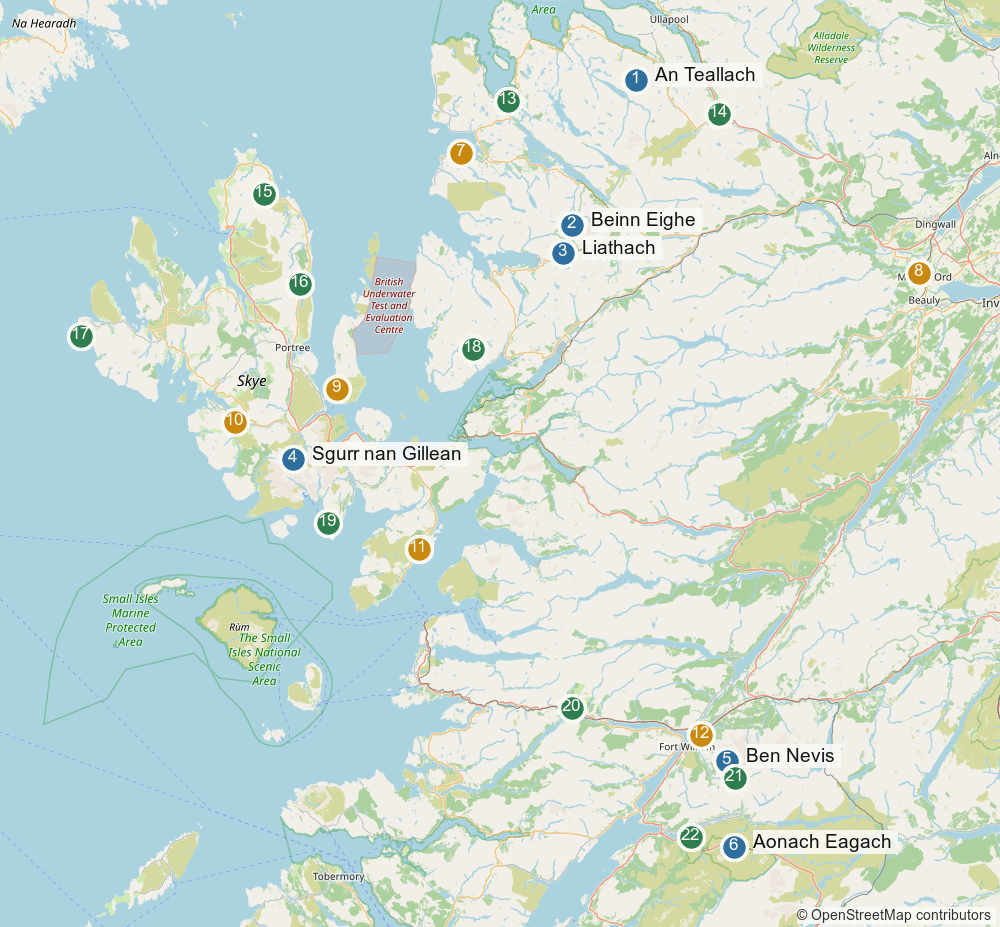
Three bases cover the seven days, each at or near a trailhead. Phone beats the booking sites for bunkhouses — most do not sync their inventory, and Kinlochewe takes bookings by phone only.
Torridon and Wester Ross. One base does An Teallach, Beinn Eighe and Liathach. Kinlochewe is 6 miles from the Beinn Eighe car park, about 15 minutes from the Liathach start, and an hour up the A832 to Corrie Hallie.
Kinlochewe Hotel Bunkhouse — 12 beds in one room, kitchen, showers, open all year. Booking by phone only, 01445 760253. Sole use is £185 a night for two nights or more, so ask for the per-bed rate.
Torridon SYHA — private rooms as well as dorms, 4 miles from the Beinn Eighe car park. Open March to October.
Ling Hut (SMC) — NG958562, in Glen Torridon beside the Coire Dubh Mòr parking, which is the Beinn Eighe approach. £20 a head, 12 beds, drying room, gas cooking. Booking by email only; see the membership note below.
Sail Mhor Croft, Dundonnell — 16 beds, ten minutes from Corrie Hallie. Ring 01854 633244 before counting on it: its website no longer resolves, though the listings are still up.
Skye. The Sligachan bunkhouse, 20 beds in four rooms, or the hotel — both stand at the Pinnacle Ridge start, in sight of the hill. The campsite runs 1 April to 30 September, so the tent only works early in the trip.
Lochaber. Fort William or Torlundy: eight minutes to the North Face car park for the three Ben Nevis routes, half an hour to Allt-na-reigh for Aonach Eagach. Glen Coe beds reverse those two numbers, and the Ben is two days out of three.
Ben Nevis Inn, Achintee — rooms with kitchenettes, drying room, food and beer downstairs. 01397 701227. It sits at the Mountain Track trailhead, not Torlundy, so still a ten-minute drive to our start.
Glen Nevis SYHA — drying room, laundry, self-catering kitchen. Glen Nevis side as well.
The CIC Hut is the prize. It stands at 680 m directly under NE Buttress, Tower Ridge and Observatory Ridge: a night there removes the 1½ to 2 hour walk-in from three of our days and puts us on the route at first light. It needs membership of a BMC or Mountaineering Scotland affiliated club and fills months ahead. Mountaineering Scotland individual membership is accepted at club huts on its own — that covers the Ling Hut too, which is most of the case for joining.
Wet days
Distilleries within reach of each base, for the days the rock is out of condition.
Skye — Talisker at Carbost on Loch Harport, distilling since 1830 and the fullest visitor offer of the lot: tour and tasting, Made by the Sea, a cask draw, Decades by the Sea. Book online. Torabhaig in Sleat and Raasay (car ferry from Sconser) are the others; the Hebridean Whisky Trail does all three in a day if nobody wants to drive.
Fort William — Ben Nevis Distillery, at the foot of the hill since 1825, which is a fair way to spend a day the mountain is out of condition. Advance booking is essential — no walk-ins. Oban and Ardnamurchan are also in reach, Ardnamurchan a full day out and back.
Torridon — Badachro near Gairloch. Gin, vodka and whisky, founded 2018 and small enough that the founders run the tours themselves: the still room, then five spirits tasted in a sunroom over the coast. Drivers get a 5 cl miniature instead of the dram. Book ahead, especially at weekends.
Driving east — The Singleton of Glen Ord at Muir of Ord. Open 10:00–17:00, but closed Monday 14 September. Signature tour, flavour-journey tastings, warehouse experiences.
Worth seeing
Non-climbing, and mostly wanting the same weather the climbing wants.
The boat from Elgol into Loch Coruisk is the standout, and precisely because we climb: you sail under the whole Black Cuillin and land in the middle of the range, seals on the way. Bella Jane or Misty Isle from Elgol jetty, 1½ to 4½ hours. Weather dependent — book, and keep a spare day.
Bealach na Bà to Applecross — the best mountain road in Britain, single track and hairpinned to 626 m, with the Applecross Inn at the far end. 7.5 t limit; no good for anything large. On the doorstep from Torridon.
Steall Falls and the Nevis Gorge — a 120 m fall up a gorge of boulders and woodland, 5.8 km and 222 m in under two hours, with a three-wire bridge across the river. Minutes from the Ben Nevis parking.
Corrieshalloch Gorge, an 1874 suspension bridge over a 200 ft slot, sits on the road out towards Inverness rather than off it. Inverewe Garden at Poolewe grows subtropical planting at 57°N, and pairs with Badachro.
Glen Coe for the Three Sisters and Signal Rock, and Glenfinnan for the viaduct — the Jacobite crosses twice a day, watchable from the viewpoint without a ticket.
Skye’s honeypots — the Quiraing, the Old Man of Storr, Neist Point. All charged now: Storr £6, Quiraing £3 for 3 hours or £5 for 6, and fines get handed out at Storr for getting it wrong. Busy, and worth less than the boat.
The finest ridge traverse on the Scottish mainland: two Munros linked by about 600 m of Torridonian sandstone pinnacles, undercut on the Toll an Lochain side so the exposure is total. Taken direct it is the hardest of the mainland big three — harder than the Aonach Eagach, harder than Liathach — but almost all of that difficulty is optional, because a bypass path runs the length of the pinnacles on the west flank.
An Teallach 1062 m — full traverse
Grade 3 scramble direct (Grade 2 on the bypass) / 15.50 km / 8:30 h / 1442 m ↗
Plan
From the Corrie Hallie layby, take the track SW, then the Shenavall path, then up the rough SE flank of Sail Liath.
North along the whole crest: Stob Cadha Gobhlach, the Bad Step, the Corrag Bhuidhe pinnacles, Lord Berkeley’s Seat, Sgùrr Fiona, Bidein a’ Ghlas Thuill.
Off the NE end over Glas Mheall Liath and down Coir’ a’ Ghiubhsachain back to the car.
Go south to north. It means you climb the Bad Step instead of down-climbing it, which is the whole point: Walkhighlands notes the final descent off Corrag Bhuidhe is a graded rock climb and the scene of several fatal accidents, and that they happen mostly in descent. The BMC says that when Dundonnell MRT is called to An Teallach it is almost always scramblers stuck at the Bad Step.
The ridge, in order
Height
Character
Sail Liath
954 m
Rounded, quartzite, no scrambling — the way on
Stob Cadha Gobhlach
960 m
Sharp top, rough walking, still non-technical
The Bad Step
—
The crux. Two short pitches of ~12 m
Corrag Bhuidhe pinnacles
1040–1049 m
~600 m of sustained sandstone scrambling
Lord Berkeley’s Seat
1030 m
Overhanging pinnacle leaning over the void
Sgùrr Fiona
1060 m
Munro
Bidein a’ Ghlas Thuill
1062 m
Munro, and the true summit
The Bad Step sits at the start of the Corrag Bhuidhe Buttress, reached after Sail Liath, the Cadha Gobhlach col and Stob Cadha Gobhlach. Two short pitches of about 12 m on rippled sandstone — frictionful, but with a sparsity of positive holds. There are three ways at it: direct (Grade 3), an easier middle line, or the flanking bypass. Steve Fallon puts the direct ascent or descent of Corrag Bhuidhe at rock-climbing Difficult, with easier ways just west of the direct line. The BMC says it takes a basic scramblers’ rack.
The bypass path runs on the west / south-west flank just below the crest, starting from the foot of Lord Berkeley’s Seat, and rejoins the ridge beyond Corrag Bhuidhe Buttress. It removes Lord Berkeley’s Seat, the pinnacles and the Bad Step, and drops the day to about Grade 2. Wikipedia’s caveat is worth heeding: it “is eroded in some places and should not be regarded as an easy option.”
Commitment
Escape is only ever to the south-west. The Toll an Lochain side is the cirque headwall, several hundred metres of cliff.
The bypass makes this technically harder but strategically less committing than the Aonach Eagach.
Getting off the mountain part-way: a very steep, loose path drops from the Cadha Gobhlach col to Loch Toll an Lochain, and past the pinnacles you can drop north from Bidein into Glas Tholl.
No fixed gear of any kind — no pegs, no abseil stations, no cables. British practice is to solo this; guides rope clients over the pinnacles.
Rock is Torridonian sandstone, with quartzite caps on Sail Liath and Glas Mheall Liath. Sources disagree on how the sandstone behaves wet — some call it grippy in the rain, trip reports say otherwise — but everyone agrees the quartzite goes greasy.
Calibration: British Grade 3 is roughly alpine PD, with the Bad Step direct feeling PD+/AD− for its few metres.
The 15.5 km figure is only valid for the true one-car round: Corrie Hallie → Sail Liath → full crest → out over Glas Mheall Liath → down Coir’ a’ Ghiubhsachain. The sting is the last part of that descent: a nasty boulder field, then steep vegetation weaving between crag bands, and a final section reported as genuinely horrendous.
Other published versions are longer and several do not finish where you parked:
Source
Start
Distance
Ascent
Time
UKHillwalking
Corrie Hallie
15.5 km
1442 m
8:30
LFTO / Trail
Corrie Hallie
20 km
1370 m
—
Walkhighlands
Dundonnell
20 km
1415 m
9–10 h
Get Lost Mountaineering
Corrie Hallie
26 km
—
11–13 h
A Glas Tholl or Dundonnell finish leaves 3.5–4 km of A832 tarmac back to Corrie Hallie — second car or a bike.
September
Daylight runs from about 14 h at the start of the month to 11 h 35 by the end, so the 8:30 h round has margin but not a lot if the ridge goes slowly. No old snow — An Teallach holds none. Midges collapse through the month, making late September a good window. Wet-day probability sits around 45%, and this is a route you want dry.
Ullapool for the full range of shops, fuel and food.
Aonach Eagach - Glen Coe
2/3 Scramble
The narrowest ridge on the British mainland, located in the Scottish Highlands.
Aonach Eagach, 967 m
Grade 2/3 scramble / 9.5 km / 8 - 9 hours / 1100 m ↗
The ridge, east to west
Height
Am Bodach
943 m
Munro Top — the downclimb off it is the first crux
Meall Dearg
952 m
Munro. The last point with any escape at all
The Crazy Pinnacles
—
The narrowest and most serious section
Stob Coire Leith
—
Ridge eases
Sgorr nam Fiannaidh
967 m
Munro, high point, and the start of the dangerous bit
Two separate cruxes. The downclimb off Am Bodach comes early and is, per the BMC, “for many people, the crux of the whole day” — awkward if you are not used to down-climbing, and there are anchors for a direct belay if anyone needs one. The Crazy Pinnacles are the real business: narrow, exceptionally exposed, and slow. Wikipedia notes “it is not uncommon for parties to take more than two hours to cross this short distance.”
Take the pinnacles direct. The BMC is explicit: “It’s best to approach the pinnacles directly rather than trying to edge your way around the side.” Same story as Liathach — skirting round them on loose ground beside the crest is not the easier option it looks like.
There is no way off
This is what makes the Aonach Eagach different from the other two ridges on this trip. It is not the hardest scrambling — An Teallach direct is harder — but it is by far the most committing.
There are no safe descents from the Aonach Eagach once embarked on this section of ridge; there have been many accidents to scramblers attempting to leave the ridge before the end of the scrambling.
Walkhighlands
The BMC puts the boundary precisely: any attempt to escape between Meall Dearg and the west end “is asking for trouble — there are no safe descent routes to the south, and the northern options will leave you stranded a long way from civilisation.” North from Meall Dearg is possible but commits you to a long, rough walk out. Past that, the only retreat is back the way you came.
So the decision point is Meall Dearg. Weather, conditions and how the party is moving all have to be settled there, not later.
The descent is the dangerous part
More people come to grief getting off this hill than on it.
Do not attempt the descent along the rim of Clachaig Gully, which has an extremely eroded and very dangerous ‘path’, the scene of several fatalities.
Walkhighlands
That path drops straight towards the Clachaig Inn and looks like the obvious way home, which is exactly the problem — it has a long accident record and features in UKH’s list of Scottish accident black spots. The steep southern slopes of Sgorr nam Fiannaidh down to Loch Achtriochtan are also best avoided.
Instead: continue west from Sgorr nam Fiannaidh, down to the bealach below the Pap of Glencoe, then the path to the road and Glencoe village. Bagging the Pap (Sgòrr na Ciche) on the way is the pleasant version and costs little.
Logistics
Start: small car park on the north side of the A82, about 300 m west of the house at Allt-na-reigh (NN174567). It fills early — there is a larger car park a short way further west.
Not a loop, and not a short walk back. Finishing over the Pap lands you in Glencoe village, roughly 2 km north of the Clachaig Inn and a long way down the glen from the car. Bus along the A82, or leave a second car in the village and start the day by riding back up.
Published figures vary with the finish taken — the page’s are Walkhighlands’:
Grade varies by source: the BMC and Trail both say Grade 2; Walkhighlands says 2/3 and adds that it is “included in some climbing guides as a ‘Moderate’ rock climb” and is “probably the trickiest scrambling on any Walkhighlands route”. Walkhighlands’ visible 5/5 rating is a walk band, not a scramble grade.
Rope: worth having someone in the party who is confident with one. The anchors for a direct belay are there at the Am Bodach downclimb and on the pinnacles. Plenty of people solo it.
It is not a loop. We would need to take the bus back to the car (or to the start).
East Buttress - Beinn Eighe
Difficult
The Triple Buttress of Coire Mhic Fhearchair is one of the great mountain features in Scotland — three quartzite buttresses set on a sandstone plinth above a loch at the back of a long walk-in. East Buttress takes a direct line up the right-hand one. Gibbs, Backhouse and Mounsey got there first in 1907 and reported “No better rock had been our fortune in all Scotland.”
Beinn Eighe, East Buttress
Difficult / ~200 m of climbing and scrambling at around grade 3 and Diff / quartzite on a sandstone plinth
The route
Reach the foot of the climbing by traversing a narrow ledge above the lower sandstone tier — not technically hard, but exposed, and worth the rope for anyone who would rather not think about it.
Then, roughly:
~80 m
Steep climbing
40 m
Scrambling
15 m
Crux corner
40 m
Scrambling
4 m
Crux crack
20 m
Scrambling to the plateau
So it is two short hard bits separated by a lot of easier ground — about four to five pitches if you rope the climbing, and moving together for the rest. It tops out on the Coinneach Mhòr plateau on the Beinn Eighe ridgeline.
Boots and wet rock
The holds are the reason both of your notes work: large holds throughout make it climbable in good boots or approach shoes, and big holds are also what makes greasy rock tolerable — there is little to slip off. That is the opposite of a slabby, friction-dependent route like Observatory Ridge, where wet rock changes the proposition entirely.
Two honest caveats. The climbing is on quartzite, which is the rock that goes greasy in the wet on Liathach and An Teallach, and guided descriptions of this route lean towards wanting it dry. So treat “doable when wet” as this route tolerates wet better than its neighbours, not that conditions are irrelevant — and the exposed entry ledge is the place where wet would matter most.
Logistics
Park at the Beinn Eighe car park on the A896, just west of the bridge over the Allt a’ Choire Dhuibh Mhòir — 6 miles from Kinlochewe, 4 from Torridon village. This is the same car park as the Coire Dubh Mòr approach.
Approach: an excellent stalkers’ path for about 7 km around the west side of Beinn Eighe, past Sàil Mhòr, to Loch Coire Mhic Fhearchair. For calibration, Walkhighlands rates the there-and-back walk to the corrie alone at 14 km / 540 m / 3.5–5 hours — so budget a long day once the climbing is added.
Descent: from the top, a short walk along the ridge, then down the south flank of Beinn Eighe to rejoin the approach path back to the car. In summer there is a bypass path through the grass about 50 m below the top of Coinneach Mhòr.
It is a genuine round from one car — no shuttle, no road walk.
Doable when wet, and can be done in walking boots.
Summer and winter are different routes here. The summer rock route is Difficult; in winter it is grade IV.
The lower tier is Torridonian sandstone, the buttresses above are quartzite. The route climbs the quartzite.
Liathach - Glen Torridon
2 Scramble
Probably Scotland’s finest mountain, challenged only by An Teallach and the Cuillin of Skye.
Liathach, 1055 m
Grade 2 on the crest, Grade 1 on the bypass / 11.5 km / 8 - 10 hours / 1326 m ↗
The ridge, east to west
Height
Stuc a’ Choire Dhuibh Bhig
915 m
Munro Top, optional detour
Stob a’ Choire Liath Mhor
983 m
Where the ascent path gains the ridge
Spidean a’ Choire Lèith
1055 m
Munro — quartzite boulders, slow going
Am Fasarinen
927 m
The pinnacles. Grade 2 direct
Mullach an Rathain
1023 m
Munro, then the descent into Toll Bàn
Meall Dearg (955 m) sits off the ridge to the north and is not part of the traverse — it is reached by the Northern Pinnacles, a 200 m Moderate rock climb on loose, shattered rock. It is quoted as “the most difficult top in the British Isles, challenged only by the Inaccessible Pinnacle.”
The bypass is not the easy option
This is the thing to know. The crest over Am Fasarinen is Grade 2; skipping it on the south-side path drops the day to Grade 1 on paper. But the path traverses natural shelves below the pinnacles and is, per Walkhighlands, “sensationally exposed, particularly at a couple of spots where it also tends to be wet.”
It is eroded, crosses gully heads, slippery when wet, and has less to hold on to than the pinnacles do. One ex-MRT member argues for sticking to the crest in poor conditions. Rain removes the easy option rather than providing one — and UK scrambles are graded dry, so wet rock pushes the whole day up.
Commitment
Escape is thin. The ascent line from the car is the last reliable bail until Mullach an Rathain. Everything north drops into the tiered cliffs of Coire na Caime.
Torridonian sandstone in near-horizontal strata — which is why the terraces and shelves exist at all — under a Cambrian quartzite cap. Wet, the quartzite goes slippery and the sandstone keeps friction but turns friable.
Some very large blocks on the pinnacles are loose or wobbly.
Coming off Spidean in poor visibility, do not follow the ridge running SSE: it ends in a precipitous prow.
The descent off Mullach an Rathain into Toll Bàn is very steep — loose scree and earth, then threading down through the sandstone tiers.
Logistics
Start: small parking area east of Glen Cottage, NG935566. Space for several cars, a few more nearer the cottage.
One car is enough. The traverse finishes at Toll Bàn about 2 km west of the start — a flat road walk on the A896. Worth doing in reverse: park at the finish (verge by the woods east of Torridon) and walk the road east while fresh. Public transport is effectively nil.
Starting instead from Coire Dubh Mòr leaves a ~4 km road return.
Published figures vary a lot — the page’s are Walkhighlands’:
Source
Distance
Ascent
Time
Walkhighlands
11.5 km
1326 m
8–10 h
Trail / LFTO
12.4 km
1665 m
—
Climb Torridon
8.2 km
1238 m
7–9 h
Steven Fallon
6 km
1280 m
—
The 1665 m is the outlier; 1326 m is the best-supported and already includes every top on the main ridge.
Links
Classic Scramble - Liathach Traverse - UKC — note this one runs west to east from Torridon village (NG920556), the opposite of the plan above, and its “plus a bit” is the South Ridge of Mullach an Rathain
Walkhighlands rates the walk 5/5 boots, its maximum. That 5 is a walk rating, not a scramble grade — the Grade 2 comes from the UKC/Rockfax logbook and is independently confirmed by Fallon, LFTO and the SMC description.
NE Buttress & Tower Ridge - Ben Nevis
Very Difficult
The North East Buttress route on Ben Nevis is a classic and striking rock climb on the mountain’s North Face.
Plan
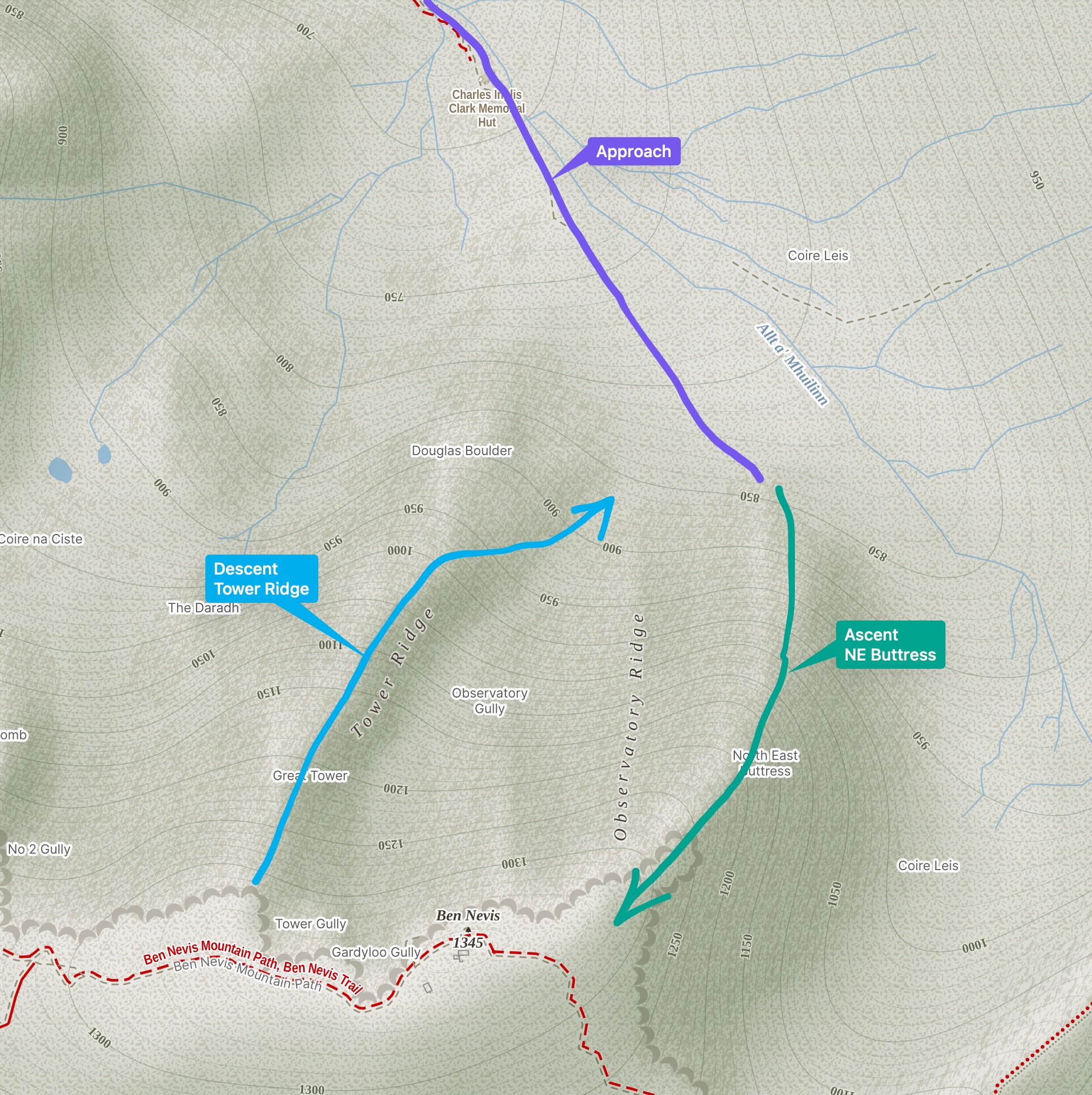
Climb the North East Buttress route (VDiff) that tops out very close to the summit of the mountain.
Traverse through the summit plateau heading for the Tower Ridge.
Scramble down the Tower Ridge (Diff).
Merge with the approach path and return to the parking lot.
Follow well marked signs from the car park to the Allt a’ Mhullinn burn and follow the path to the Charles Inglis Clark (C.I.C.) Memorial Hut (1.5 to 2 hours).
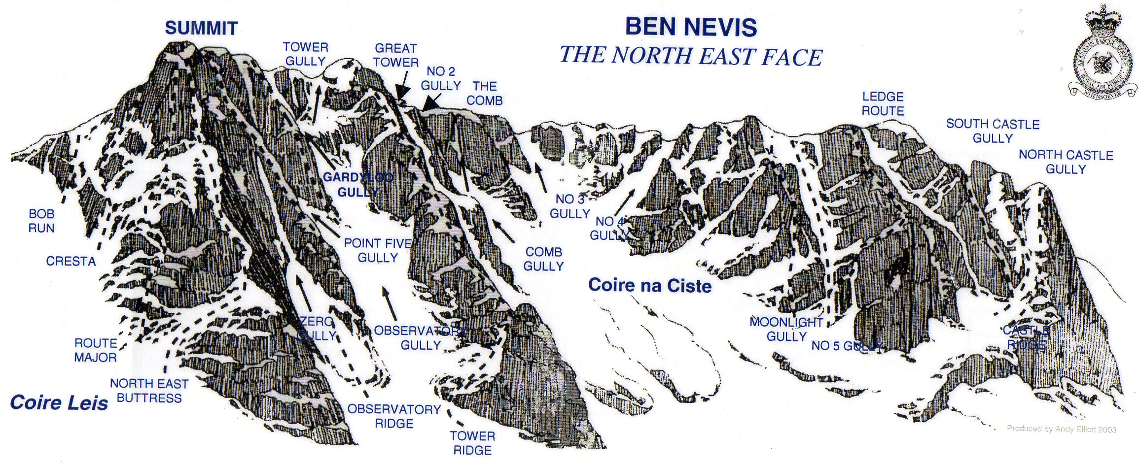
From CIC: North East Buttress is the massive furthest left buttress on the crag
Tower Ridge is the massive ridge rising out of the Douglas Boulder.
The rock becomes extremely slippy and greasy when wet, best tackled in dry weather.
Observatory Ridge - Ben Nevis
Very Difficult
Harold Raeburn soloed this in June 1901, and it still feels like the serious one of the Nevis ridges. It rises straight out of Observatory Gully between Zero Gully and Point Five Gully, and tops out on the plateau within metres of the summit and the ruined observatory — closer to the top than Tower Ridge manages.
Ben Nevis 1345 m, Observatory Ridge
Very Difficult / 400–500 m / ~4 pitches then 250 m+ of grade 3 scrambling / andesite & basaltic lava
Plan
Walk in from the North Face car park to the CIC hut.
Continue south-east past the Douglas Boulder into Observatory Gully to the toe of the ridge.
Pitch the lower four rope-lengths, then move together up the long upper section to the summit plateau.
Descend Coire Leis and rejoin the Allt a’ Mhuilinn path back to the car.
The route
Around four pitches of real rock climbing low down, then at least 250 m of grade 3 scrambling with occasional harder steps to the plateau — that shape is consistent across every account. It is too long to pitch throughout in a September day, so the upper section is moving together or short-pitching.
Both cruxes are turned on the right. The lower pitches weave across slabs and corners as the ridge narrows, and a steep, imposing wall is bypassed on the right in a fine position before regaining the crest. A second tricky pitch higher up, again on the right, overlooks Observatory Gully. No source publishes a pitch-level technical grade for either.
Dry rock is a requirement, not a preference. The lower section is slabby and friction-dependent, and being less travelled than Tower Ridge it stays greasy: “the rock becomes extremely slippy and greasy when wet, so this is a route best tackled in dry weather” (Lochaber Guides). The Highland Mountain Company put it more plainly — “you really need the rock to be dry on this ridge, as there are quite a few slabby footholds that do require a bit of friction in the lower sections.” The north face needs a few settled dry days to come into condition at all.
The rock is andesite and basaltic lava, not granite — the granite on Ben Nevis is elsewhere on the mountain, not in these cliffs.
How it compares
Ridge
Grade
Length
Tower Ridge
Difficult
~600 m
North East Buttress
Very Difficult
~400 m
Observatory Ridge
Very Difficult
400–500 m
Commitment
No abseil is published anywhere on the route, and no escape line.
No fixed gear.
Loose rock on the ridge needs care, and it is greasier than Tower Ridge when damp.
North Face car park → CIC hut (680 m) up the Allt a’ Mhuilinn, roughly 5–5.4 km. Published times run from 1 h 20 with a light sack to over 2 h with a climbing sack.
From the hut, head south-east past the Douglas Boulder (the foot of Tower Ridge) and up into Observatory Gully to the toe of the ridge. No reliable published time for this leg — budget generously, and expect old snow: the upper reaches of Observatory Gully hold snow into September most years.
Timing
Guides meet clients at the North Face car park at 07:00–07:30 for this route. Around 10–11 hours car to car is the figure that circulates, though nothing authoritative is published.
The north ridge of Sgùrr nan Gillean and the hardest of the three ridges to its summit: five pinnacles taken in turn, with an abseil off the third. Described as one of the best routes of its grade anywhere in the country — around 600 m of scrambling and easy climbing in spectacular positions.
Sgùrr nan Gillean 964 m, Pinnacle Ridge
Grade 3 / Difficult / 11.2 km / 9 hours / 1029 m ↗
The five pinnacles
1st
From a shoulder at the mouth of Coire a’ Bhasteir, zigzagging ledges — good scrambling following lines of basalt through the gabbro
2nd
A quick, easy walk
3rd
The main scrambling, up a steep basalt staircase, a few short rope-lengths. The abseil comes off the far side
4th
Knight’s Peak, 914 m
5th
The summit of Sgùrr nan Gillean
The abseil
This is the logistical crux, and it settles the rope question: off the third pinnacle, a tricky start from the fixed chain onto a steep slab, then 22 m of slab down to the col.
Take a 50 m rope. Reports are explicit that a 50 m was fine, but that reaching right down into the nick of the col needed the full 50 m doubled.
Wikipedia notes the ridge “requires a climber to have a rope and harness and be capable of abseiling, unless the third pinnacle is omitted by bypassing on the east side” — so there is a way to skip it, and it is worth knowing where that bypass is before committing.
Descent
Reverse the South-East Ridge, the Tourist Route, a Grade 3 rock scramble in its own right — the summit sits at the junction of the West Ridge, Pinnacle Ridge and the South-East Ridge, and the West Ridge also needs ropework, so it is not the soft way off.
Logistics
Start and finish at Sligachan - parking lot. Sgùrr nan Gillean is visible from the village.
Skye Guides put the route at 8 hours guided; the report the figures above come from took 9.
Note the geography: this is the one objective on the list that is not on the mainland, and it is a long drive from Torridon and further from Glen Coe. Worth pairing with something else on Skye rather than treating it as a day trip.
Grade varies by source and by system: Skye Guides give “Grade 3/Difficult”; it is traditionally a 3S in scrambling grades, which under the newer scale has become grade 4; as a climb it is called Mod/Diff. Wikipedia simply calls it a rock climb. It is a step up in seriousness from An Teallach.
Rock is gabbro with basalt intrusions — the basalt lines give the scrambling its staircases, and they are the bits that go slippery when wet.